
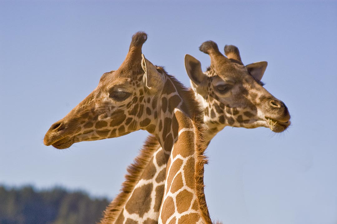
 Issue #106 - California Wine Country After you explore and photograph the wine country, allow at least a day to visit Safari West, located just north of Santa Rosa, California, and several miles southwest of Calistoga, off Mark West Springs Road at Porter Creek Road. At Safari West, you can easily fill several days photographing hundreds of African, South American, and Asian animals roaming 480 acres of a wooded, private preserve. Giraffes graze in wide-open paddocks, and African spoonbills preen their feathers. The facilities are designed to allow close-up photography of exotic birds—East African crowned crane, ostrich, griffon vultures, saurus crane, and the scarlet Ibis. To see and photograph the animals roaming the savannah environment, sign on for one of the guided Safari Truck tours. These tours use four-wheel-drive safari vehicles to take small groups into the hills of the preserve and operate on a regular schedule throughout the year: three times a day in summer season, two times a day in winter season. Their Jeeps allow great photo access to the exotic and endangered wildlife—African Cape buffalo, springboks, eland, zebra, scimitar horned Oryx, addax, red lechwe, and blue wildebeest. If you plan to fly into the area, check out the flights into Sacramento International Airport. The drive to Napa in the wine country from Sacramento is about the same distance as from San Francisco International Airport, but you won’t have to drive through The City.
You can find more information on California Wine Country in Issue #106 Page 11 of Photograph America Newsletter. 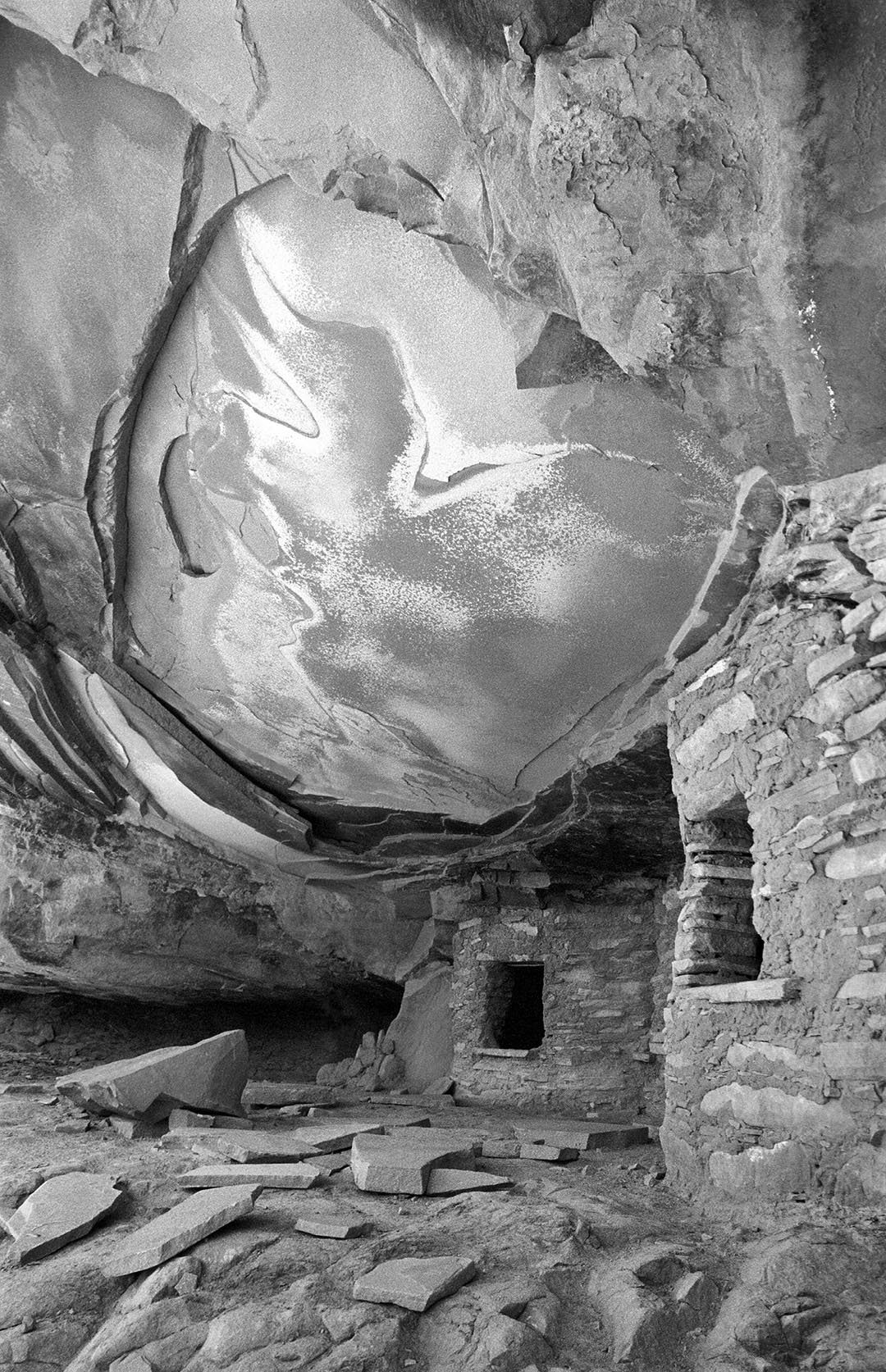 Issue #077 - Two Weeks in the Desert, Utah The directions to Road Canyon Road, in Utah’s Grand Gulch Wilderness Area, are in my Photograph America Newsletter #77. Road Canyon ruin is set deeply enough into its protective alcove that even at high noon on November 3rd, the sun was high enough in the sky to be completely off this ruin. The best time to arrive here is midmorning. Later in the afternoon, the sun drops lower in the western sky and strikes this canyon wall directly, spoiling the whole effect. This is not a good spot for a sunset. A cloudy or overcast day will probably illuminate the site adequately but you won’t have the warm light reflecting up and into the alcove from the slick rock below the ruin. A warming filter, or an adjustment to your digital camera’s white balance setting would be very useful for this location. Do not touch the ruins or remove anything. My GPS unit indicated a distance of 0.4 miles from the parking area to the bottom of Road Canyon and another 0.57 miles from the cairn at the bottom of the trail to the ruin. It took forty minutes to hike from the car to the ruin and fifty minutes for the uphill return. This hike took a total of three hours, including photography time.
You can find more information on Two Weeks in the Desert in Issue #77 Page 10 of Photograph America Newsletter. 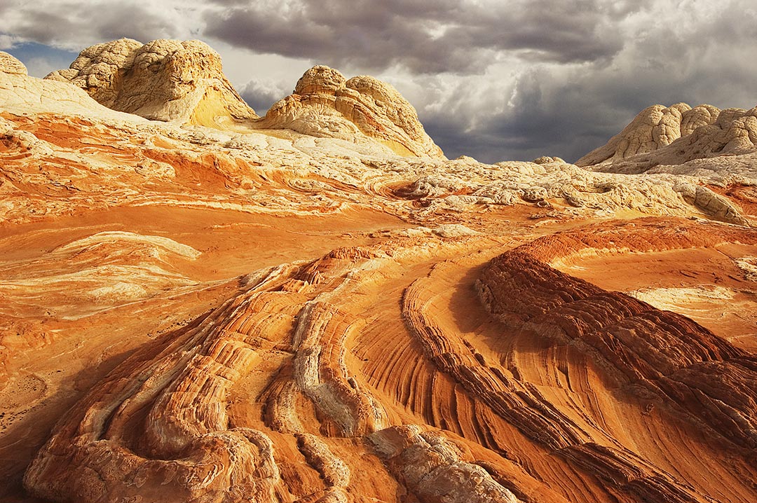 Issue #105 - Arizona's White Pocket The formation called “White Pocket” is a half-mile long, north to south, and a quarter-mile wide, east to west. White Pocket is a unique spot on the northern edge of Arizona, a few miles east of The Wave, and one of those remote locations photographers are always searching for. Five miles east of the Cottonwood Cove Trailhead on the east side of the South Unit of Coyote Buttes Wilderness area, White Pocket is not easy to reach. No permit is needed to visit White Pocket, but the BLM may change that policy. White Pocket has a hard, thin sandstone crust covering a core of red Navajo sandstone. The light-colored crust is almost completely covered with patterns of narrow cracks, dividing the surface into four, five, and six-sided polygons, each slightly raised in the center, like a pillow. In some places, the white crust has been torn open to reveal the underlying red sandstone. Huge mounds rise all over the rolling terrain, resembling the exposed brains of ancient underground creatures.
You can find more information on Arizona’s White Pocket in Issue #105 of Photograph America Newsletter. |