
 Issue #143 - Photographing at the Zoo This flamingo was photographed at the Sacramento Zoo. Most zoos open at 10:00 am, after the best morning light is gone. Arrive at the entrance before the gates open. You’ll find a better parking space, and most of the animals are more active in the morning. Summer mornings at some zoos can be foggy, providing much better lighting for photography than contrasty, midday lighting. Get your hand stamped at the gate so that you can return your heavy jacket to your car when the sun comes out. Since you’ll be walking all day, wear comfortable shoes. Wear black clothing to eliminate reflections on plexiglass enclosures. Pack a black t-shirt in the side pocket of your camera bag. This is also a must-have item for helicopter.
Skip your Africa trip this year and read Issue #143 - Photographing at the Zoo.  You can find more information on California Wine Country in Issue #106 Photograph America Newsletter. By late October, the vineyards across the Napa and Sonoma Valleys have turned yellow. By the second week of November, the remaining leaves change to shades of red. Here, in the San Francisco Bay Area, you will discover landscapes similar to the rolling hills of the Palouse in southeastern Washington State and autumn color as vivid as New England’s. Intertwine your photography with wine tasting tours through the area’s famous wineries and a few of the best restaurants in America. This newsletter includes directions to my favorite spots for sunsets across the vineyards of Northern California.
 You can find more information on Bears of Fish Creek in Issue #65 Photograph America Newsletter. Fish Creek, a few miles north of Hyder, Alaska, is the prime salmon spawning stream in southeastern Alaska. In August and September, black bears and grizzlies head for Fish Creek to feast on spawning chum and sockeye salmon. To photograph black bears, grizzlies, and bald eagles, plus some of the most dramatically rugged landscapes you’ll ever see, there is no better place to visit than southeastern Alaska. Starting in Seattle, you can drive 900 miles to Hyder, Alaska, on paved roads in less than three days. The landscape photography in Hyder, Alaska, is as exciting as the wildlife photography. The road to the glaciers north of town is even more exciting than the Ice fields Parkway to Jasper in the Canadian Rockies.
 You can find more information and photos of each of the waterfalls at Ricketts Glen in Issue #118 Page 1 of Photograph America Newsletter. In northeastern Pennsylvania, on the southern edge of the Appalachian Plateau, mountain streams have cut deep gorges through old-growth forests of pine, oaks, and hemlock Fast-flowing cascades, (like the Delaware Falls above) drop a thousand feet down the Allegheny front in a series of dramatic waterfalls before they unite at the bottom and flow into the Susquehanna River. There, at Ricketts Glen State Park, is an overabundance of dramatic waterfalls, some as tall as ninety feet. In late April, most of this forest’s deciduous hardwoods have no foliage to block your view of the waterfalls. The vistas are not all monochromatic. Spring color is provided by ferns and moss growing on the walls of the glens and the many large evergreens–pines and hemlocks. In early spring, the streams are at their fullest and the falls are most dramatic. A loud and constant roar is heard. Through the middle of Summer, the bugs are at their worst and the trails are filled with tourists. The campgrounds are open and rental cabins are available for visitors. By Autumn, the summer crowds have gone, the falls have almost dried up, and the constant roar heard in the spring is gone. That’s when a 4-stop (1.2) neutral density filter is useful. With much longer exposures, a few small trickles multiply to give the appearance of more water flowing over the falls. The peak of autumn color usually arrives in this park around the middle of October on the birch, beech, cherry, maples, and oaks. The park is open through the Winter for cross country skiers, ice fishing, snowmobiling, and winter camping. The Falls Trail is closed by snow and ice through the winter.
 You can find more information on Florida Wildlife Refuges in Issue #78 Page 11 of Photograph America Newsletter. After four days in the Tampa area, I headed north on US 19, up the Gulf Coast, looking for more wildlife refuges. A few, like Homosassa Springs, are worth a second look. Homosassa Springs State Wildlife Park, on the Gulf Coast, seventy-five miles north of Tampa, is a rehabilitation center for endangered West Indian manatees that have been orphaned or injured in the wild or have been born in captivity. In addition to all the manatees, there are shorebirds, pelicans, herons, storks, wild turkeys, cranes, and egrets, there’s a variety of hawks (above), owls, and bald eagles in natural-looking environments. There are native bobcats, black bears, otters, foxes, and most of the birds native to Florida. Most of these bird enclosures are close to the trails. Photographers using a 400mm telephoto can easily fill their viewfinders with tight head shots. Many of the enclosures are open, so you won’t be shooting through wire mesh or bars. After paying the entrance fee, you can explore the grounds all day, photographing at your own pace. Park rangers roaming the trails can answer your questions. Carry your longest telephoto to capture close-ups of the birds and the alligators. A shorter lens, even a wide-angle, is necessary to photograph the large manatees through the windows in the underwater observatory. Use an extension cord or raise your flash head high enough to prevent problems with reflections on the underwater windows. Using a digital camera, you can double check your exposures and flash settings as you go. Get your hand stamped at the gate, and you can come and go all day. Park visitors can take a jungle cruise upriver to the source of the springs. There’s a cafe, a gift shop, and free parking in the paved lot. The park is just north of the small, historic fishing village of Homosassa, where lodging and restaurants can be found. For more information, do an Internet search for Homosassa Springs.
 You can find more information on Mt. St. Helens in Issue #60 Page 5 of Photograph America Newsletter. If you are traveling north or south on Interstate 5 take Exit 68 and drive east on Highway 12 to the town of Randal where you’ll turn south for 19 miles toHeading north or south on Washington Forest Road 25, watch for the sign marking Iron Creek Falls. It is across the road from a sign warning of the approaching junction of FR99. This spot is 19.5 miles south of the village of Randle. There’s a wide, unpaved parking area on the east side of the road. The trail to the falls drops a hundred feet down a long string of wooden steps. Iron Creek Falls shoots out through a notch in the black basalt cliff and falls thirty feet into the middle of a large pool. The dark cliff face makes an excellent background for the bright spray of water. There are several good tripod locations on the near side of the stream. To discover the only access to the eastern side of Mount St. Helens, continue driving south on Forest Road 25, and take the first right turn onto Forest Road 99. A large brown sign marks the turn onto this side road. For several miles, the road passes through lush, old growth red cedar and Douglas fir groves. This part of the forest was just far enough away from the volcano to survive the blast and the shock wave of hot gasses. The first marked turnoff at Bear Meadows, on the left side of FR99, offers an excellent view of Mount St. Helens in the distance, framed by Douglas firs. This is the first viewpoint of the mountain along this eastern access road. From this angle, you’ll see the best light on the mountain in the early morning.
 Issue #010 - Into the Everglades, Florida The Shark Valley Trail is located thirty miles west of Miami on the northern boundary of the Everglades National Park. The loop trail, a narrow paved road, follows a canal that flows south from Highway 41 (the Tamiami Trail). The Shark Valley Trail is fifteen miles long. Half-way around the loop is a sixty-five foot observation tower. On the top of the tower, you will be standing in the heart of the Everglades. The panoramic views of the sawgrass prairie from the tower are worth the trip. The exciting photography involves the wildlife! All along the trail are alligators. I counted over sixty, including several new-born ’gators only ten inches long. Large turtles are swimming with huge alligators in the pond beneath the observation tower. All the birds you expect to see can be found (and easily photographed) in the trees around the waterhole. You can take a narrated tram ride. The tram stops for twenty minutes at the observation tower, and you will not have enough time for any serious photography. You are allowed to walk the whole trail but fifteen miles is too far to walk with a camera and tripod, even though the trail is absolutely level. If you have a half-day free before catching an afternoon or evening flight home from Miami International, consider renting a bicycle at the Shark Valley Visitor Center. With a bicycle with a large basket, you can travel at your own pace and stop anywhere along the trail. Alligators holes can be found all along the trail.
You can find more information on The Everglades in Issue #10 Page 11 of Photograph America Newsletter.  Issue #082 - Anza-Borrego Desert Landscapes, California A ranger at California’s Anza-Borrego Desert State Park Visitor Center told me about a fascinating formation of round stones called the “Pumpkin Patch.” Located in a remote area just outside the eastern boundary of the park in the Ocotillo Wells State Vehicular Recreation Area, this hillside is covered with round, pumpkin-sized stones. Late afternoon light was casts long shadows across the round concretions. Some are split open and others are slightly oblong and misshapen, like a pumpkin. Many are perfectly round and smooth. I used a 15mm lens to exaggerate the relationship of nearby and distant stones. You will need a map from the Visitor Center to find this location. Late afternoon light was casting long shadows across the round concretions. Some are split open and others are slightly oblong and misshapen, like a pumpkin. Many are perfectly round and smooth. If you get lost, remember that your cell phone will work out there.
You can find more information on Anza-Borrego Desert in Issue #82 Page 10 of Photograph America Newsletter. 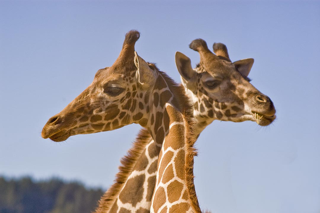 Issue #106 - California Wine Country After you explore and photograph the wine country, allow at least a day to visit Safari West, located just north of Santa Rosa, California, and several miles southwest of Calistoga, off Mark West Springs Road at Porter Creek Road. At Safari West, you can easily fill several days photographing hundreds of African, South American, and Asian animals roaming 480 acres of a wooded, private preserve. Giraffes graze in wide-open paddocks, and African spoonbills preen their feathers. The facilities are designed to allow close-up photography of exotic birds—East African crowned crane, ostrich, griffon vultures, saurus crane, and the scarlet Ibis. To see and photograph the animals roaming the savannah environment, sign on for one of the guided Safari Truck tours. These tours use four-wheel-drive safari vehicles to take small groups into the hills of the preserve and operate on a regular schedule throughout the year: three times a day in summer season, two times a day in winter season. Their Jeeps allow great photo access to the exotic and endangered wildlife—African Cape buffalo, springboks, eland, zebra, scimitar horned Oryx, addax, red lechwe, and blue wildebeest. If you plan to fly into the area, check out the flights into Sacramento International Airport. The drive to Napa in the wine country from Sacramento is about the same distance as from San Francisco International Airport, but you won’t have to drive through The City.
You can find more information on California Wine Country in Issue #106 Page 11 of Photograph America Newsletter. 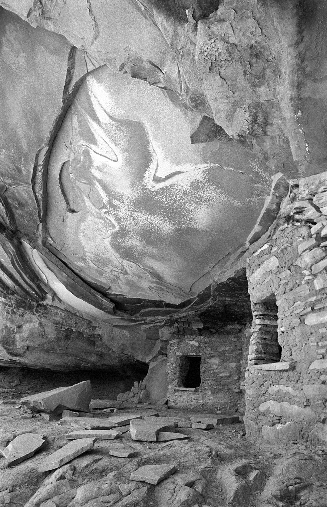 Issue #077 - Two Weeks in the Desert, Utah The directions to Road Canyon Road, in Utah’s Grand Gulch Wilderness Area, are in my Photograph America Newsletter #77. Road Canyon ruin is set deeply enough into its protective alcove that even at high noon on November 3rd, the sun was high enough in the sky to be completely off this ruin. The best time to arrive here is midmorning. Later in the afternoon, the sun drops lower in the western sky and strikes this canyon wall directly, spoiling the whole effect. This is not a good spot for a sunset. A cloudy or overcast day will probably illuminate the site adequately but you won’t have the warm light reflecting up and into the alcove from the slick rock below the ruin. A warming filter, or an adjustment to your digital camera’s white balance setting would be very useful for this location. Do not touch the ruins or remove anything. My GPS unit indicated a distance of 0.4 miles from the parking area to the bottom of Road Canyon and another 0.57 miles from the cairn at the bottom of the trail to the ruin. It took forty minutes to hike from the car to the ruin and fifty minutes for the uphill return. This hike took a total of three hours, including photography time.
You can find more information on Two Weeks in the Desert in Issue #77 Page 10 of Photograph America Newsletter. |